 Location: 3725 S. Scott Blvd
Support Facilities: Parking lot
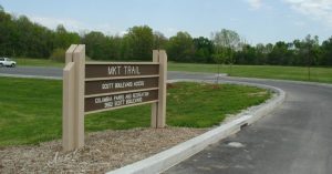 Location: 3800 S. Scott Blvd.
Support Facilities: Drinking fountain, Parking lot, Restroom (open year round), Bike fix-it station, Information Kiosk
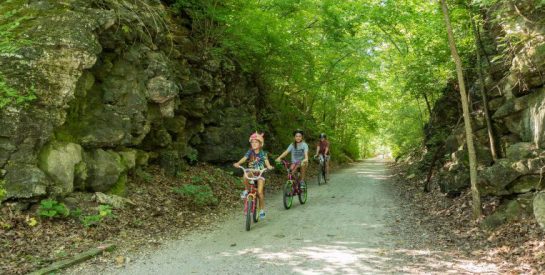
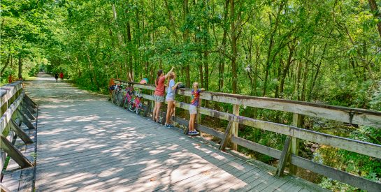
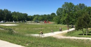
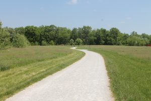
These approximately 5 acres located just southeast of the intersection of the MKT Trail and Scott Blvd. have been developed into an open field that can be used as a soccer practice area. A 34-car parking lot was constructed off Scott Blvd. to serve this area as well as providing access to the MKT Trail. The MKT Trail connects to the County’s portion of the MKT trail at this access through an underpass that leads to the west side of Scott Blvd. The County’s portion of the trail is 4.2 miles and connects to the cross-state KATY Trail.
 Location: 2701 Forum Blvd.
Support Facilities: Drinking fountain, Parking lot, Restroom
Location: 501 S. Providence Rd.
The MKT Trail Plaza was constructed in 2009 and funded by GetAbout Columbia as part of the Stewart and Providence intersection improvement project. The plaza is located in a triangular green space bounded by accesses from Providence Road, Stewart Road, and the MKT Trail. A seating area with a drinking fountain and four benches that face the creek and a commemorative plaque offers an ideal place for trail users to take a rest or meet up with friends.
James T. Scott Memorial Plaque
Members of the Association of Black Graduate and Professional Students solicited donations to have a marker placed in the plaza in memory of James Scott, a 35-year-old black man who was lynched by a mob from the Stewart Road Bridge in 1923. Scott was married at the time and working as a janitor at the MU medical school when he was accused of raping the 14-year-old white daughter of an MU German professor. Mr. Scott proclaimed his innocence to the end and never received his day in court.
On September 30, 2016 over 100 people attended the unveiling of the plaque marking the site of the lynching. Haeny, a speaker at the plaque unveiling and one of the board members of the Association, said, “Let this marker serve as a reminder of the continued work needed to end the racial injustices in our community and beyond.”
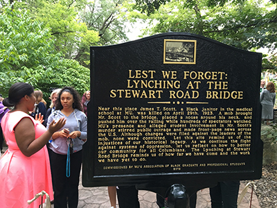
The inscription on the plaque reads as follows:
LEST WE FORGET:
LYNCHING AT THE STEWART ROAD BRIDGENear this place James T. Scott, a Black janitor in the medical school at MU, was killed on April 29th, 1923. A mob brought Mr. Scott to the bridge, placed a noose around his neck, and pushed him over the railing while hundreds of spectators watched. MU’s presence and alleged student involvement in Mr. Scott’s murder stirred public outrage and made front-page news across the U.S. Although charges were filed against the leaders of the mob, none were convicted. Let this site remind us of the injustices of our historical legacy. As we continue the fight against systems of oppression, let us reflect on how to better our community for all Columbians. The Lynching at Stewart Road Bridge reminds us of how far we have come and the work we have yet to do.
COMMISSIONED BY MU’S ASSOCIATION OF
BLACK GRADUATE AND PROFESSIONAL STUDENTS
2016
Location: 101 S. 4th St.
Support Facilities: Drinking fountain, Parking, Bike fix-it station
101 S. 4th St.
(park area at 4th St. and Locust St.) – Phase I
400 Locust St.
(park area between Locust St. and Elm St.) – Phase II, Trailhead with street parking and parking lot off Elm St.
The rails-to-trails movement
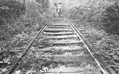
The Rails-to-Trails movement and open space preservation began in the early 1970s when the City adopted a comprehensive greenway plan. This plan inventoried all available open spaces, concentrating on undeveloped watersheds.
The Hinkson and Flat Branch Creeks contained the right-of-way (ROW) of the 8.5 mile Missouri-Kansas-Texas (MKT) railroad line from Columbia to McBaine.
Acquisition
In 1977, MKT railroad abandoned the right of way. The following year, Columbia Parks and Recreation Department applied for and received a grant for $240,000 from the Railroad Revitalization and Regulatory Reform Act from the United States Department of Interior. The estimated cost to purchase and develop the land was $275,000. Columbia was one of the first 10 pilot projects in the US.
Between 1979 and 1982, the City agreed to purchase the quit-claim deed from the railroad for $17,725 but the railroad only owned about 25% of the right of way. So, the City began the arduous task of buying the remaining right of way from individual landowners. This process was much more time consuming and expensive than planned. Several landowners were opposed to the project and filed suit to stop it.
The grant was renegotiated to include only the 4.3 mile section from Stewart Road to Scott’s Boulevard.
Development
The trail was developed in three phases:
Phase I
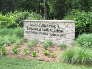
The first phase, which opened in 1982, was the 3.3 mile section from Stadium Boulevard to Scott’s Boulevard. The Stadium Boulevard site was a former City sewage treatment plant. The plant was converted to a trailhead park and site of the Martin Luther King Jr. Memorial. The plant’s control building was converted into an interpretive center managed by the Audubon Society and restrooms. In the first mile from Stadium towards Forum Boulevard, a 20-station exercise/fitness course was installed. This was funded by the Wells Fargo Gamefield Fitness Campaign.
Phase II
The second phase, which opened in 1983, was the 1.03 mile section from Stadium to Stewart and Providence Road. This section was able to be opened due to the cooperative agreement between the City and the Missouri Highway and Transportation Commission. When Route 740 (Stadium) was renovated and widened, a walkway was constructed under Stadium Boulevard which provided safe passage.
Due to the potential legal problems concerning landowner rights, the trail was not officially dedicated until October 13, 1985.
Phase III
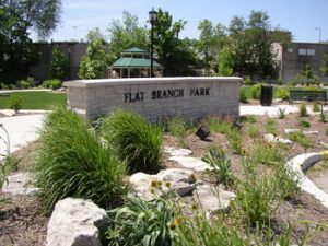
Providence Road to the intersection of Fourth and Cherry Streets, opened in 1991. This section, known as the Downtown section of the trail, is constructed entirely of concrete. The Fourth and Cherry Street site is the home of the downtown Flat Branch Park. The 1/4 acre trailhead park features the Flat Branch Creek that borders the property, as well as a gazebo, benches and tables, sidewalks, landscaping, historic markers, and greenspace. The groundbreaking ceremony took place May 6, 2000. Construction was completed in November 2001, and the dedication ceremony was on November 15, 2001.
Costs
Phases I and II, Stewart Road to Scott’s Boulevard, acquisition and development: $482,000 (approximately 70% funded by grants).
Phase III, Providence Road to 4th & Cherry Streets: $35,000.
Buffer land along the MKT Trail
Developers, recognizing the economic benefits of the MKT Trail began to develop home and commercial sites immediately adjacent to the MKT Trail. Since the MKT Trail is a linear 100-ft wide trail, development could literally be 50 feet from the center of the trail and be legal. Friends of the MKT Trail, a nonprofit organization, recognized the need to preserve land next to the trail, lobbied and gained support from the City to begin acquisition of buffer land.
Financing for this land acquisition was made possible by passage of a 1/4-cent sales tax in 1991. Approximately 350 acres have been acquired. Buffer land acquisition and development costs (Forum Nature Trail $50,000 and Forum parking lot enlargement $50,000) are approximately $1.5 million.
Forum Nature Area opened in fall 1996. This 2.0 mile trail was developed as part of buffer land acquisition project. It is for pedestrian traffic only. No cyclists are permitted.
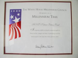
MKT designated as millennium trail
In 2000, thousands of trails across the country were recognized as Community Millennium Trails under the Millennium Trails initiative. The MKT Trail was officially designated as a Community Millennium Trail. A certificate of recognition signed by First Lady Hillary Rodham Clinton was received and the trail was listed on the Millennium Trails web site and in a national trails database. Millennium Trails is a partnership among the White House Millennium Council, the Department of Transportation, Rails-to-Trails Conservancy, the National Endowment for the Arts and other public agencies and private organizations. The goal of Millennium Trails is the creation of a nationwide network of trails that protect the natural environment, interpret history and culture, and enhance alternative transportation, recreation and tourism.
Community Millennium Trails were recognized on National Trails Day, June 3, 2000 in a grand nationwide celebration organized by the American Hiking Society. Each year, this stirring event showcases trails and their places in our lives and communities. In 2000, it also celebrated Millennium Trails.
Martin Luther King, Jr. Memorial at Battle Garden re-dedication
Date: August 28, 2006
Martin Luther King, Jr. Memorial at Battle Garden Dedication Program
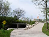
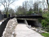
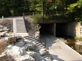
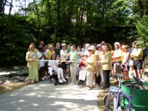
Stewart/Providence/Elm underpass project dedication
Date: May 12, 2007
MKT Stewart/Providence/Elm Underpass Project Dedication Program
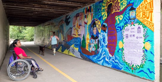
MKT Trail 2016 mural dedication
Date: August 2, 2016
2016 Dedication Program
MKT Trail 2017 mural dedication
Date: August 1, 2017
2017 Dedication Program
Agency management change for MKT Trail section from Scott Blvd. to the Katy Trail
Date: June 6, 2020
In 2020, the Boone County Commission formalized an agreement with the City of Columbia regarding the management of the MKT Trail generally from Scott Boulevard to its intersection with the Katy Trail. As per the agreement, the City of Columbia will undertake the current maintenance obligations of the 4.2-mile trail section east of Scott Blvd.