Table of Contents
About Bear Creek Trail
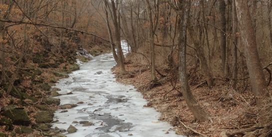
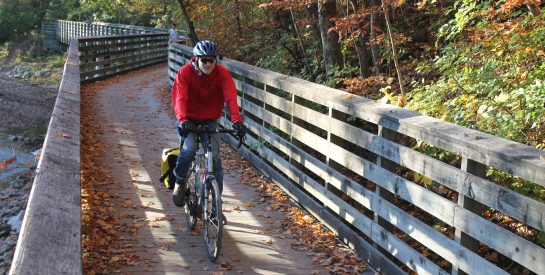
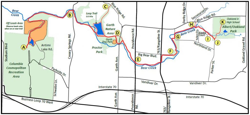
The Bear Creek Trail is located in northern Columbia and links two of the city’s most popular large parks, the 533-acre Columbia Cosmopolitan Recreation Area and the 81.5-acre Albert-Oakland Park. In general, the trail follows the natural drainage system of the Bear Creek and runs in an east/west direction across the northern part of the city. The limestone trail is approximately 4.8 miles in length.
- Trail Miles: 4.8 miles, limestone
- Support Facilities: parking, restrooms, bicycle repair station at trailhead in Garth Nature Area
- Bear Creek Trail Mapopens PDF file
- Trail Guide Brochureopens PDF file
Trailheads & connectors
 opens PDF file
 Location: opens in a new window1615 Business Loop 70 W.
Trail Miles: Bear Creek Trail 4.8 miles, limestone; Rhett’s Run Mountain Bike Trail, 4.1 miles, dirt single track; Cosmo Nature Trail, 1.3 mile, dirt
Support Facilities: Parking, restrooms
This trailhead, located in the northwest corner of Cosmo Park, services the Bear Creek Trail, Rhett’s Run Mountain Bike Trail and the Cosmo Nature Trail. Parking is available at trailhead near the Columbia Skate Park. Restrooms are available at various locations in the park from April 15-October 15. (See map of Cosmo Park.)opens PDF file A year-round port-a-pot is available near the Skate Park.
As you leave the parking lot, approximately one-half mile of the Bear Creek Trail winds through the Bear Creek Nature Area where one can frequently see beavers and other wetland wildlife. The nature area in the north of Cosmo Park is a leash-free area for dogs, except for on the Bear Creek Trail. Dogs must be on a four-foot leash when on the Bear Creek Trail.
Location: opens in a new windowParkside Dr.
This trailhead is located just north of the Antimi Sports Complex and services the Bear Creek Trail, Rhett’s Run Mountain Bike Trail and the Cosmo Nature Trail. Restrooms are available at various locations in the park from April 15-October 15. (See map of Cosmo Park.)opens PDF file The parking lot may not be available during league play for youth baseball/softball league. During this time, please use the Cosmo Park Trailhead near the Skate Park.
Location: opens in a new window3201 Creasy Springs Rd.
Trail Miles: 4.8-mile Bear Creek Trail
Support Facilities: Parking, port-a-pot
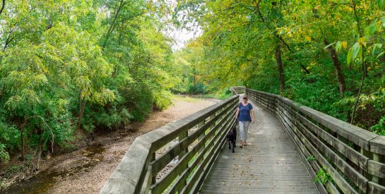
This trailhead is located off Creasy Springs Rd in north Columbia. The Bear Creek Trail heads both east and west from this location. Trail users traveling east toward the Garth Nature Area and Albert Oakland Park will encounter the beautiful 450-foot boardwalk just after passing under Creasy Springs Rd. Heading west from this trailhead will take you to Cosmo Park. While the entire trail is relatively flat, the short section just north of Cosmo Park has a 15 – 18% grade.
The boardwalk was one of the most challenging features in the construction of the two phases of the trail that were built by Columbia Parks and Recreation construction staff. The boardwalk was built on the side of a rocky tree-lined bluff with minimal impact on vegetation. The structure required 18 concrete support structures that had to be hammered into solid rock and constructed at the edge of Bear Creek.
This section of the trail from Creasy Springs to the Garth Nature Area includes a bridge over Bear Creek that provides a spectacular view of the creek below and a close-up view of the beautiful flora that grows on the Missouri limestone bluffs.
Location: opens in a new windowBear Creek Trail Connector
Trail Miles: 0.2 mile
This connector runs from Python Ct. to W. Prairieview Dr. where trail users can use the sidewalk along W. Prairieview Drive and Creasy Springs Road to gain access to Bear Creek Trail.
This concrete connection to the Bear Creek Trail from Python Ct. was completed in 2011. The project was federally funded and administered by GetAbout Columbia. The combined cost of the Python Ct. and Blue Ridge Connectors was $526,000.
Location: opens in a new windowBear Creek Connector
Trail Miles: 0.3 mile
The Blue Ridge Rd. Connector gives residents in the Vanderveen Subdivision access to the Bear Creek Trail from Blue Ridge Rd. This concrete trail can be accessed from the south side of Blue Ridge Rd. between Snow Leopard Dr. and Sea Eagle Dr. and connects trail users to the wetland loop trail in Garth Nature Area. This connection provides a pleasant journey through preserved green space.
As trail users enter Garth Nature Area, they can continue around the gravel wetland loop trail to join up with the Bear Creek Trail and either travel west toward the Creasy Springs Trailhead or east toward Albert-Oakland Park. (Map of Garth Nature Areaopens PDF file ).
The Blue Ridge Rd. Connector was completed in 2011. The project was federally funded and administered by GetAbout Columbia. The combined cost of the Python Ct. and Blue Ridge Rd. Connector projects was $526,000.
Location: opens in a new window2799 North Garth Ave.
Trail Miles: 1.0 mile (approx.), limestone
Support Facilities: parking, restroom, bicycle repair station and air pump, information kiosk
This phase extends a distance of about 1 mile from Garth Avenue eastward to Hwy. 763. The trail runs along the north side of Bear Creek throughout this distance, and there are no bridges on this section of trail. The trail routes safely underneath Garth Avenue, so users don’t have to cross the road. A bicycle repair station and air pump are located near the trailhead kiosk across from the dog park.
The Garth Avenue parking lot also serves the Garth Nature Area, which has looping gravel trails around a wetland area connecting to the Bear Creek Trail. A fenced dog park is also located southwest of the parking lot.
Location: opens in a new windowNorth Providence Rd
Trail users will find easy access to the Bear Creek Trail while traveling south or north on N. Providence Rd. This access location is south of Big Bear Blvd.
Location: opens in a new windowParker St.
C. M. Albert Memorial Park, located in the southern portion of Albert-Oakland Park, can be accessed from the north end of Parker St. Trail users can access Bear Creek Trail to the west from this portion of the park. Where the trail enters the park is the 4.8 mile marker for the trail, with Cosmo Park being the 0.0 mile marker. (See Map of Bear Creek Trailopens PDF file .) To the east of the trail is one of two disc golf courses in the park. (See Map of Albert-Oakland Parkopens PDF file .)
Location: opens in a new window2799 N. Garth Ave.
Trail Miles: 1.6 miles, limestone
Support Facilities: parking, restrooms, bicycle repair station and air pump
A gravel trail loops from Bear Creek Trail to the north encircling a wetland area. An abundance of birds and other wetlands wildlife make this an interesting walk. The north wetlands loop trail is 0.5 miles in length. The distance between points where the wetlands loop leaves and re-connects to the main trail is an additional 0.2 mile making the total loop 0.7 miles in length. From the parking lot around the north wetland trail and back is 1.1 miles.
Winding gravel trails around the south wetlands provide an enjoyable experience for trail users and their dogs. This area was constructed in 2006/2007 and funded by a Recreational Trails Grant in the amount of $42,000 and $28,000 from the Park Sales Tax. Another $14,400 funded by the Park Sales Tax was used to construct the fenced leash-free area for dogs. This fenced 3-acre area encompasses a pond and has picnic tables on site.
Trail history
Phase I Dedication: October 30, 1999
Phase IV Dedication: November 4, 2001
The preliminary planning for Bear Creek Trail began as part of the City’s Greenbelt Plan in the early 1990’s, and the trail concept was included in the City’s 1994 Parks and Recreation Master Plan. The detailed planning took place in 1994-95 with the initiation of right-of-way acquisition for Phase I in late 1996.
The trail was developed in four phases for a total length of 4.8 miles. The total budget for the trail was $1,235,777. This budget included funding from Transportation Enhancement Grants, the City of Columbia’s 1/4 Capital Improvement Sales Tax, and support from the City’s General Fund.
Development of the trail began in 1996 and was divided into four phases. Phase 1 – Garth to Creasy Springs and Phase II – Creasy Springs to Cosmo Park were completed by Parks and Recreation. Public Works managed the construction of Phase III – Garth to Hwy. 763 (Rangeline St.), and Phase IV – Hwy. 763 (Rangeline St.) to Albert-Oakland Park. The final phase of the trail was completed in 2001 and the trail was dedicated on November 4, 2001.
Capital improvement projects and council items
| year completed | project description | council items |
|---|---|---|
| 2001 | Bear Creek Trail Development (P&R: Phaes I & II; PW: Phases III & IV) | |
| 2002 | Purchase 0.2 acre lot on Alaska Court for trail access | |
| 2005 | Public Works: Garth Avenue Bridge Reconstruction (included routing trail underneath bridge) | |
| 2011 | GetAbout Columbia: Python Court Connector | |
| 2011 | GetAbout Columbia: Blue Ridge Drive Connector | |
| 2015 | New Trailhead Restroom at Garth Nature Area | View Council Item |